
Take a hike across San Diego County—from scenic trails to adventurous day trips.
From heart-pounding climbs up to mountaintop vistas, to pleasant treks through miles of grasslands and fragrant sage scrub, San Diego County is the premier place to take a hike. In fact, the region is crisscrossed by more than 250 designated hiking trails. Following are just a few favorite areas with multiple hiking opportunities. Coastal and some upper-elevation mountain hikes are suitable year-round; while inland and foothills hikes are best from October through May (during which you’ll beat the heat and enjoy maximum seasonal foliage).
Some tips before you set out: Always bring more water than you think you’ll need—especially if you’re hiking with a canine buddy. Because of the presence of rattlesnakes and coyotes (and possibly other predators), always keep your dog leashed. Also, be sure to visit the websites for each locale in advance for hours, safety updates, closures and restrictions due to the pandemic. Finally, don’t forget the sweat-proof sunblock. Happy hiking!
Hollenbeck Canyon
At 6,100 acres of rolling hillsides of coastal scrub and rock outcroppings, former ranchland Hollenbeck Canyon is one of San Diego’s best kept hiking secrets. The main trail is about 4.5 miles out and back; starting off in an open meadow, above which hawks and other raptors often soar. The trail soon changes dramatically, following along a flat, riparian area. Its small stream (which can become a raging torrent during winters of plentiful rain) is bordered by magnificent live oaks and stately sycamores. Leaving the shade of the streambed and becoming somewhat rocky, the trail gradually climbs up several hundred feet in altitude along the eroded wall of a steep gorge—with views of the imposing Otay Mountain and Lyons Peak ahead, and a sweeping vista of the seemingly endless expanse of the valley behind. It then drops back down to an oasis of green trees along the streambed—an idyllic spot to stop for a rest before turning back. Honey Springs Road, just off Campo Road and Hwy. 94, Jamul.
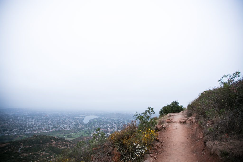
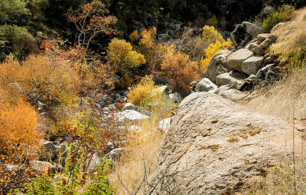
Mission Trails Regional Park
Considered one of the three “jewels” of the San Diego Park system (Mission Bay Park and Balboa Park are the other two), the 68,000-acre Mission Trails Regional Park offers both the serious hiker and the casual walker more than 60 miles of trails of varying degrees of difficulty in a beauty-filled natural environment. Some of these trails climb the rugged, boulder-strewn hills; some cut through one of the last expanses of natural grasslands in the San Diego area; some follow the stream that eventually becomes the San Diego River; and some pass by ancient flat rocks with the indentations of the morteros and metates used for centuries by the Kumeyaay Indians to grind their acorns and seeds. The park also includes the 1,593-foot-high Cowles Mountain—a cardio-workout trail with mountain-to-ocean views for a reward at the summit. Leashed dogs are allowed on trails. 1 Father Junipero Serra Trail, San Diego (the park stretches between the Mission Gorge, Tierrasanta, and San Carlos neighborhoods and the towns of Santee and La Mesa).
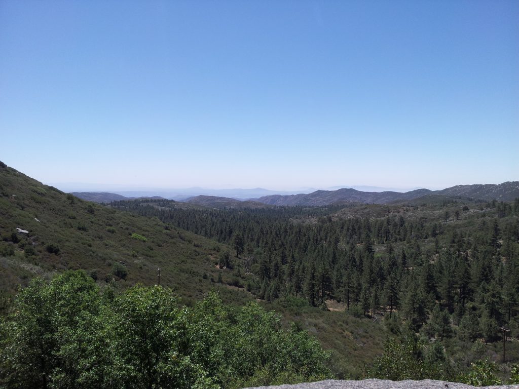
Mount Laguna
Only an hour’s drive east from downtown San Diego, the 6,000-foot-high Mount Laguna is a playground for hikers and nature lovers. Located within the purview of the Cleveland National Forest, the mountain’s 70-plus miles of trails include a section of the Pacific Coast Trail, which passes over the crest and for several miles edges close to the peak’s eastern escarpment—with spectacular views of the Anza-Borrego Desert lying far below. The higher elevation and forests of Jeffrey pine trees make for cooler hiking during hot weather than other inland trails. And when winter brings snow to the mountains, it is a prime spot for cross-country skiing and snowshoeing. Some favorite trails include the 6-mile-long Big Laguna, which passes through meadows often strewn with wildflowers. (Also, around Laguna Lake lies a tranquil pond, the depth of which depends on time of year and rainfall.) The 10-mile Noble Canyon Trail runs from Sunrise Highway downhill to Pine Valley, following creeks and shady glens. The views all around are simply postcard-perfect. Laguna Mountains, Sunrise Highway and Los Huecos Road, Mount Laguna.
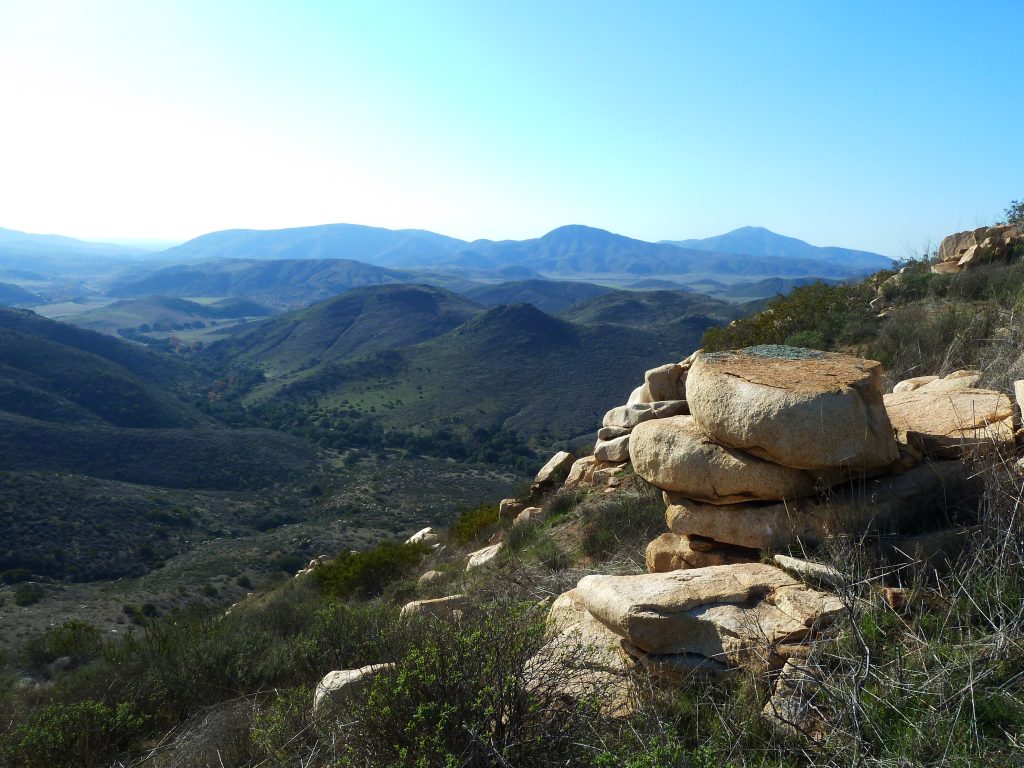
San Dieguito River Park
Don’t let the Escondido address fool you; San Dieguito River Park encompasses 50,000 acres that include the 65-mile Coast to Crest Trail network that stretches from Del Mar to Lake Hodges and the foothills of Poway and Escondido, to the river’s source at Volcan Mountain, north of Julian. There’s something for everyone. Highlights include the Del Mar River Path with the San Dieguito Lagoon Boardwalk and viewing platform; the Lake Hodges pedestrian/bicycle bridge, which is the longest stressed-ribbon bridge in the world; panoramic views from the top of Bernardo Mountain; Piedras Pintatas Trail near Lake Hodges, with a couple of waterfalls and the site of Kumeyaay rock paintings; San Pasqual Valley’s Raptor Ridge; and views from Volcan Mountain that, on a clear day, can extend from the ocean to Anza-Borrego Desert and the Salton Sea. 18372 Sycamore Creek Road, Escondido.
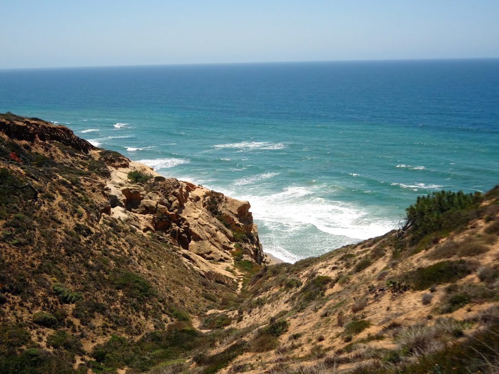
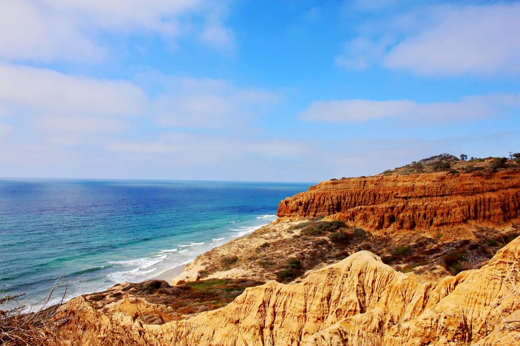
Torrey Pines State Natural Reserve
Arguably the most breathtakingly picturesque beach in San Diego County, Torrey Pines State Natural Reserve has the distinction of being equally enjoyable when experienced from its wide sandy shores, or from the trails that traverse the tops of the dramatic, 300-foot-high sandstone cliffs that front the beach. On a warm day, there’s no better beach hike than the approximately 4 miles (each way) from the park entrance south to Scripps Pier, stopping at will for a cooling dip in the surf. In the reserve on the cliffs above, there is a network of eight different trails, including two that make the steep descent to the beach—varying in length from 100 yards to more than a mile—that can be combined for longer hikes. Depending on the trail, you will pass through coastal scrub and chaparral, through a grove of the rare and endangered Torrey Pines for which this reserve is named, and along gorges and interesting formations carved out of the sandstone by natural erosion. Keep in mind that while the reserve is open, the visitor center remains closed, and dogs are not allowed anywhere in the park. 12600 N. Torrey Pines Road, La Jolla.
Photo credits: Mission Trails Regional Park by Tim King. San Dieguito River Park by James Coffee Studio.